Welcome to RogersCityWeather.com
Shortcut alias for this site is rcwx.tech

NovaLynx Gauge status: NovaLynx Rain gauge fully operational with cover off.

|
Updated: @
18-Apr-2024 11:23pm
|
| Summary / Temperature |
Wind |
Rain |
Outlook |

|
Overcast
|

|
45.7°F

Cold
Feels like:
46°F
24-hr difference
35.1°F |
| |
Today |
Yesterday |
| High: |
52.3°F
1:39pm
|
48.6°F
1:09am |
| Low: |
43°F
12:05am
|
40.3°F
2:49pm |
|
|

|
SW
2
Gust:
4.9 mph
|
|
1 Bft -
Light air
|
|
Today:
25.9 mph
4:05am
|
|
Gust Month: 40.9 mph
April 17
|
|
| Rain Today: |
0.01 in
|
| Rain Rate (/hr): |
0 in
|
| Rain Yesterday: |
0.39 in
|
| This Month: |
3.07 in
|
| Season Total: |
7.7 in
|
|
Friday

Chance Rain
then Partly
Sunny and
Breezy
|
|
| Humidity & Barometer |
Almanac |
Moon |
| Humidity: |
88 %
|
| Dew Point: |
42.3°F
|
| Barometer: |
30 inHg
|
| Baro Trend: |
Falling Slowly
|
|
| Sunrise: |
6:43am |
| Sunset: |
8:25pm |
| Moonset: |
4:59am |
| Moonrise: |
3:11pm |
|
|
Waxing Gibbous |

|
80%
Illuminated |
|
| UV Index |
Solar Radiation |
|
0.0
None
|
|
High: 4.2 @ 12:31pm
|
|
|
0 W/m2
(0 %)
|
|
High: 751 @
5:03pm |
|
| NWS Weather Forecast - Outlook: Tonight & Friday |
Tonight

Rain Likely
Lo 43 °F |
NWS forecast: Rain likely, mainly before 5am. Cloudy, with a steady temperature around 43. Calm wind becoming south around 5 mph. Chance of precipitation is 70%.
Davis VP+ forecast: Increasing clouds with little temperature change. Precipitation possible within 24 to 48 hours. |
| |
Friday
Chance Rain
then Partly
Sunny and
Breezy
Hi 47 °F |
NWS forecast: A 30 percent chance of rain before 8am. Cloudy, then gradually becoming mostly sunny, with a high near 47. Breezy, with a west wind 10 to 20 mph, with gusts as high as 30 mph. |
|
Quick jump to forecast for the week
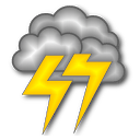 Current Great Lakes Lightning Map From Blitzortung
Looking for USA map? It's here.
Michigan Lightning
Local Lightning
Current Great Lakes Lightning Map From Blitzortung
Looking for USA map? It's here.
Michigan Lightning
Local Lightning
Smokey Says Today's Fire Danger is
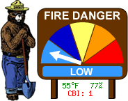 Note that since this station is close to Lake Huron, temperatures can be lower and humidities can be higher than further inland. Fire conditions can vary greatly even a few miles away.
Fire Danger Map
High Moisture Limitations:
With PM2.5 sensors, fog reflects the light, and can result in a higher reading. This is
characteristic to the inherent sensor design.
The condition occurs during rainy or foggy weather, where:
Outdoor Temperature - Dew point Temperature ≤ 2 ℃ 3.6 ℉
Ambient Weather PM25 Air Quality Monitor here at Station Location
Convert to AQI
Purple Air Air Quality Monitor two blocks West of here
Loading PurpleAir Widget...
We are hosting a lightning sensor for TOA Systems.